2022-23 Winter League #7 – Point Defiance Park
WINTER LEAGUE
Saturday, February 4 at Point Defiance Park in Tacoma, WA
- ALL runners will be called to enter the start procedure line 10 minutes prior to their assigned/picked start time. Please Be Race Ready when your name is called.
- Pre-registration is required. There is no day-of-event registration.
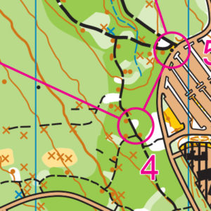
- Site Map is here.
- The list of START TIMES is Here.
Winter League is the Pacific Northwest’s premier competitive orienteering series for all ages.
- Elementary, Middle School, High School and College students compete under the banner of the Washington Interscholastic Orienteering League (WIOL).
- Winter League public courses offer a range of categories from a competitive long advanced category to non-competitive beginner-friendly categories at every event!
COURSES
Course designer(s): Chris Cooper
| Controls | Length | Climb | |
| Elementary/Beginner | 11 | 1.5 km | 15 m |
| Middle School | 12 | 2.0 km | 35 m |
| JV Rookie/Advanced Beginner | 13 | 2.4 km | 45 m |
| JV Female/Intermediate | 15 | 3.0 km | 55 m |
| JV Male | 16 | 3.1 km | 60 m |
| Varsity | 17 | 3.9 km | 115 m |
| Short Advanced | 18 | 4.1 km | 125 m |
| Intercollegiate/Long Advanced | 19 | 5.1 km | 155 m |
How are courses measured?
Courses are measured as the crow flies, in a direct line from control to control. Unless you have wings, you will travel farther than this distance! Courses are measured in kilometers, so a good rule of thumb is to simply round up to miles to estimate how far you will go. So in a 5 kilometer race, you’ll likely travel up to 5 miles.
COURSE NOTES from Chris Cooper:
General Information:
- Since the last WIOL event at Point Defiance, there have been two substantial changes to the park’s road system. The first change is that the outer loop roadway has now been closed to vehicle traffic. The second change is the relocation of the Owens Beach (event parking) entrance and exit.
- The closure of the outer loop is good news for orienteers and means that those running elementary, middle school and the JV courses will not have to contend with vehicular traffic.
- The realignment of the Owens Beach exit and entrance might cause drivers pause on their way to the event. The old one-way entrance has now been closed and the new entrance relocated 350m further along the loop road. The new entrance has now been combined with the beach parking’s exit road. Not to worry, there are plenty of signs directing you to Owens Beach. The site map properly depicts the new roadway configuration
- It is a 250m walk from the parking lot to the start. The walk is predominantly uphill so plan accordingly.
- Due to the changes with the Owen’s Beach entrance, the “Start” configuration has been substantially altered from past events. Take advantage of John’s RunningWilds (found on Cascade’s training page) for an up to date view of the Point Defiance map changes.
- Unlike the shorter courses, Varsity, Short and Long Advanced will cross the live traffic of the inner loop roadway. There are no designated crossing points so, please take care when crossing all roadways south and east of Owens Beach.
- The parks department has realigned the trails along the park’s western cliff line. The trail systems no longer hug the top of the cliffs. In addition, the park staff has added fences where spur trails lead to the cliff edge. There are no controls near the cliff edge so please respect the trial changes and fence additions.
- The Varsity and advanced courses will cross the pathway to the start tents. A crossing guard will be stationed at the intersection. Please give crossing runners the right-of-way.
The Courses:
- The base map scale for the Point Defiance map is set for 1:10,000. However, the event map scale is set for 1:5,000 for Elementary, 1:7,500 for the middle school and JV courses and 1:10,000 for varsity and the advanced courses.
- There is no shortage of features along the trails at Point Defiance Park. Keep an eye out for parallel errors due to mistaken attack points.
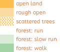
- Vegetation can change rapidly from open forest to dense vegetation and back again. Those changes can happen faster than a 1:10,000 map will reflect. Vegetative areas have been updated to best reflect the overall run-ability of an area.
- There are countless deer and social trails running throughout the park. I have done my best to map the more distinct trails. However, not all small trails are reflected on the map.
- To protect the park’s vegetation, all controls have been set on the park’s main trails, on social trails or on the bare forest floor. Whenever possible, please use the trails or vegetation free areas to access the controls. Avoid trampling vegetation whenever possible.
- Elementary controls will be set on the approaching side of all features. However, runners should see the feature before they see the control. The goal is to focus on identifying features and less on the control bag.
- Middle School runners may travel up to 15m from the main trail to reach the control. Although, all controls can be seen from the main trail and have a clearly identifiable attack point.
- JV runners will have multiple route choices between controls. Knowing when to cut trails and when to take the long way around will be crucial.
- Varsity and Intercollegiate will have controls with limited back stops and handrails. A compass and good pace count might be the solution to randomly wandering around the forest looking for a control.
- Have fun and enjoy the beauty of this unique metropolitan park!
SCHEDULE
This event is Pre-Registration Only
8:45 am PreRace Training Begins
9 am – Info Tent and Newcomer Instruction Opens
9:35 am – Start process begins
9:45 am – First start
12:45 pm – Last Start
1:00 pm – Post Race training begins
2: 45 pm – Course Closure
Why is there a start window?
This event uses an interval start, which means that participants are started in waves instead of all at once. When you arrive at the start tent, find the chute for your course and follow the start volunteer’s instructions.
PRICES
PUBLIC COURSE PRE-REGISTRATION PRICES
$22 base price
– subtract $5 for CascadeOC members
– subtract $5 for using your own e-punch
Become a member here.
Participating as a group? Just $5 for each additional adult (16+) group
member, no cost for additional minors.
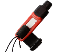
What’s an e-punch?
An e-punch records your race. At each control, you’ll dip the e-punch into an electronic box, which will beep and flash as confirmation. After you finish, you’ll download the e-punch at the download tent and get a receipt that show which controls you visited and how long you took between each; these are your “splits.”
Part of the fun of orienteering is comparing your splits with people who completed the same course, and discussing the routes you took!
SIGN UP
Public registration will close Wednesday 2/1/2023 at 11:59:00 PM.
There is no Day-of-event registration.
Remember to also sign up for a start time for public runners.
LOCATION
PARKING
Parking is at the Owens Beach Parking Lot. See Site Map here.
CARPOOL
Looking for a carpool? Join the Yahoo listserv and share your request to find a ride.
SAFETY & ETIQUETTE
Return to the Finish
All participants MUST return to the finish and download their e-punch or turn in their punch card.
Even if you have not finished your course, you must still return to the the finish and confirm with event staff that you have returned safely.
Out of Bounds
Some areas may be marked out of bounds. It is imperative to respect these boundaries to maintain our relationships with land managers. Participants MUST NOT go out of bounds. Any participant caught going out of bounds will be disqualified.
Course Closure
All participants MUST return to the finish by course closure time. If a participant does not return by course closure, event volunteers will begin coordinating a search party.
If you need a long time on the course, start as early in the start window as possible, wear a watch, and be prepared to cut your course short to make it back by the course closure time.
Whistle
All participants MUST carry a whistle on the course. Complimentary whistles are available at the start tent (please only take one).
If you are injured on the course and need assistance, blow three long blasts to call for help.
If you hear a call for help, abandon your course to find the person in distress.
Voices
Part of the fun and fairness of orienteering is navigating your own course, so please be polite when you find a checkpoint and don’t holler that you’ve found it.


