2021-22 Winter League #5 – Shoreview Park/Shoreline College
WINTER LEAGUE
Saturday, January 8 at Shoreview Park/Shoreline CC in Shoreline, WA
Meet Director: Julia Morse
The event has been posted on the UsynligO app, https://usynligo.no/. Zoom in the map to Shoreview; it is the event that was posted Jan 9, 2022. (And check out the other three events at Shoreview Park / Shoreline College.)
The 2021-22 Winter League Series Rules and Information have changed due to COVID. Please read all the important information
for the Public Procedures/Rules here and for the WIOL Procedures/Rules here.
**THERE IS NO DAY OF MEET REGISTRATION**
Shoreview Meet Documents:
Winter League is the Pacific Northwest’s premier competitive orienteering series for all ages.
- Elementary, Middle School, High School and College students compete under the banner of the Washington Interscholastic Orienteering League (WIOL).
- Winter League public courses offer a range of categories from a competitive long advanced category to non-competitive beginner-friendly categories at every event!
COURSES
Course designer(s): Dave Tallent
WIOL Courses:
| Controls | Distance | Climb | Anticipated winning time | Spectator control & sprint loop | |
| Elementary | 12 | 1.4 km | 20 m | 14 min | Yes |
| Middle School | 13 | 1.7 km | 40 m | 15 min | Yes |
| JV Rookie | 14 | 1.9 km | 50 m | 19 min | Yes |
| JV Female | 14 | 2.0 km | 70 m | 21 min | Yes |
| JV Male | 15 | 2.2 km | 70 m | 22 min | Yes |
| Varsity | 17 | 2.7 km | 125 m | 31 min | Yes |
| Intercollegiate – JV | 15 | 2.2 km | 70 m | 22 min | Yes |
| Intercollegiate – Varsity | 21 | 3.7 km | 130 m | 35 min | No |
Public Courses:
| Controls | Distance | Climb | Anticipated winning time | Spectator control & sprint loop | |
| Beginner | 12 | 1.4 km | 20 m | 14 min | Yes |
| Advanced Beginner | 14 | 1.9 km | 50 m | 19 min | Yes |
| Intermediate | 14 | 2.0 km | 70 m | 21 min | Yes |
| Short Advanced | 17 | 3.1 km | 80 m | 40 min | No |
| Long Advanced | 21 | 3.7 km | 130 m | 35 min | No |
How are courses measured?
Courses are measured as the crow flies, in a direct line from control to control. Unless you have wings, you will travel farther than this distance! Courses are measured in kilometers, so a good rule of thumb is to simply round up to miles to estimate how far you will go. So in a 5 kilometer race, you’ll likely travel up to 5 miles.
COURSE NOTES
Map Scale: 1:4,000
Map:
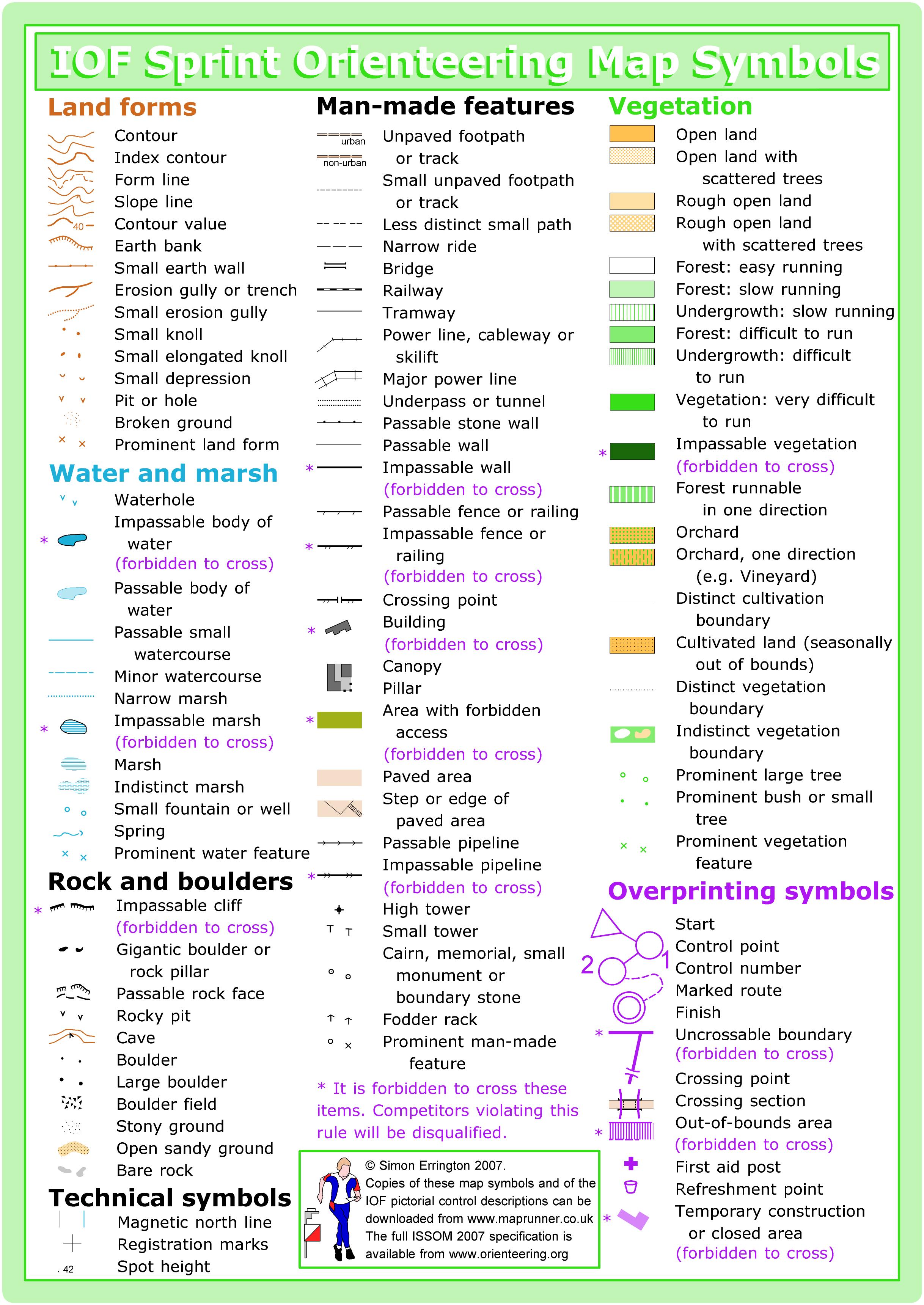
All but the college has been almost completely remapped at a scale of 1:4,000, with new LIDAR contours. The map uses the ISSprom2019 mapping standard, with a couple of symbols from the ISOM2017-2 set (vehicle track, foot trail, small foot trail) and a couple of non-standard symbols (brush pile and fallen tree) added to make the map much easier to read in the forest areas. Specifically, the one-size-fits-all 2m wide unpaved path/track sprint symbol has been replaced in the forest. The campus is mapped entirely with Sprint symbols. On your control description, a circle with an X inside is a stump, a few are large topless trees, just trunks. These are shown as a green X on your map.
The Park/The terrain:
This pair of back-to-back urban parks just west of Shoreline College offers some very tall trees, small creeks, and a network of (mostly) good trails with a few ups and downs. Wildflowers, ferns, moss, birds: they are all here.
Six distinct forested areas were noted during mapping: conifer forest; conifer/deciduous forest; conifer/madrone forest; deciduous forest; riparian forest and landscaped forest. Non-forested habitats include large areas of shrubland, grassland, landscaped grassland, open water (Hidden Lake), and developed areas. The shrublands consist of Scotch broom, Himalayan blackberry, and butterfly bush. Other invasive species found include English ivy, herb Robert, and yellow archangel.
Many steep and erosion-prone slopes are present in the parks, particularly in the riparian forests along the stream corridor. As a result, riparian areas have the lowest densities of trees, snags, and shrubs in the park. Note the out-of-bounds areas on your map. Please minimize any damage and erosion on hillsides by staying on the mapped hillside trails.
Courses:
Shoreview is hilly. I have tried to avoid two of the nasty steep hills. I have also chosen potential routes and features which should be a new experience for many of you.
This meet has a “Run out” start: Once you have punched the start punch box (on the sawhorse at map handout area), you will follow a 50m taped (or pin flagged) route which will take you out of sight of runners waiting to start. At the end of the tape/pin flags, there will be a control marker without a punch box (this is the triangle on your map). You need to pass within 1 m of that start marker and then you are free to go your own way.
There will also be a spectator control, so your adoring parents and friends can take photos and cheer you on.
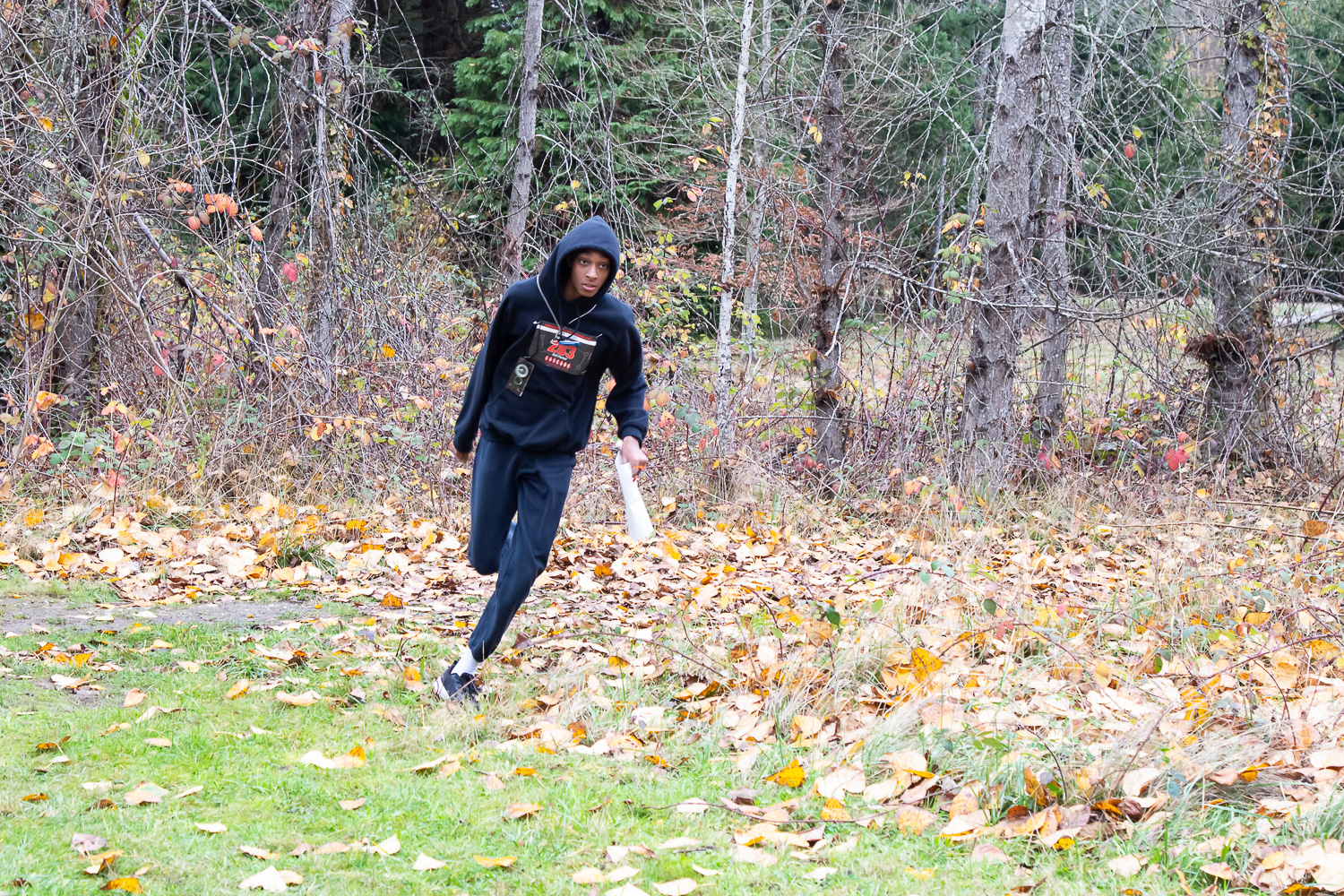
Te terrain is hilly with the full spectrum of run-ability – from open forest to thick ground vegetation. When planning your routes, check for steep hillsides and dark green vegetation. Go around. I have designed your course to maximize run-ability and minimize bushwhacking. Many of you have run here before. However, expect to travel in parts of the park that are new to you. I hope all your control locations are new to you. Reading contours, reading vegetation boundaries, pace counting, and following a compass bearing and total map engagement will be tested. A few controls will be set on campus. With the expected poor weather and hilly terrain, I have aired on the side of shorter courses.
Specifically:
Courses 1 to 6 have a spectator control near the start/finish, an opportunity for parents and friends to cheer you on (bring your cowbells) and snap a photo capturing your joyful engagement in the sport of orienteering. Once you have punched at the spectator control, follow the tape to the edge of the soccer field. At this point, you will enter a final 350m 3 control sprint loop to the finish. So don’t be alarmed at the total number of controls on your course. Courses 7 and 8 do not have the spectator control or the sprint loop. You will most likely be crossing paths with other courses. Check your control code number. It’s not fun to work hard and then mis-punch.
Courses 1,2,3 are a small “step up” from previous courses at this level. I’ve emphasized, observation, speed, and fun. These three courses also have a mandatory road crossing near the main entrance to the park. There will be a crossing guard. Please obey their instructions, especially if told to STOP. They are there for your safety.
Course 1, introduces a few simple route choice decisions, but in an area close to the ballfields. If you get lost just go to the ballfield or parking area.
Course 2 and 3, controls just a few meters off handrails emphasizing lots of route choice btw most controls. If a control says rootstock, you most likely will need to look behind it.
Courses 4 and 5. You will most likely see the feature before you see the control flag. Read the description carefully, noting where the control bag is located in relation to the feature.
Courses 6 and 8 are physical and most locations will hopefully be new to you. However, for Course 7 I have been gentle to be more accommodating for our older club members.
It will be an adventure. Have fun and whether you are fast or slow, enjoy the experience, but please return by 2:30 pm!
Dress: I recommend spikes or running shoes with good traction. The hills could be wet and muddy. One’s feet should remain dry when crossing streams. But with that said, expect severe weather and wet feet. It could also be very cold. Bring a change of clothing for after the race. Dress for cold and maybe hypothermic weather. Be safe and smart.
SCHEDULE
**Due to COVID – ALL Public and WIOL participants will have assigned start times**
9:45 am – Assigned starts begin
12:45 pm – Last possible assigned start time
2:30 pm – Course closes
PRICES
PUBLIC COURSE PRE-REGISTRATION PRICES
$22 base price
– subtract $5 for CascadeOC members
– subtract $5 for using your own e-punch
-running as a group? Add $5 for each additional adult (16+) group member, no charge for additional children. Max group size is 3 due to COVID restrictions.
Become a member here.
**Due to COVID, there will be no day of meet onsite registration for Winter League 2021-22.**
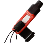
What’s an e-punch?
An e-punch records your race. At each control, you’ll dip the e-punch into an electronic box, which will beep and flash as confirmation. After you finish, you’ll download the e-punch at the download tent and get a receipt that show which controls you visited and how long you took between each; these are your “splits.”
Part of the fun of orienteering is comparing your splits with people who completed the same course, and discussing the routes you took!
SIGN UP
Online pre-registration RSVP dates:
- The deadline for Meet Registration for public that wants to request a start time is Tuesday pre-meet at Noon.
- The deadline for Meet Registration for public not requesting a specific start time is Wednesday pre-meet at 9pm.
- Friday evening pre-meet at 7pm all COVID attestation forms are due.
LOCATION
PARKING:
Parking is at Shoreview Park. There are 143 parking spots there. Parking may be tight during certain times, please plan accordingly.
THE MAP
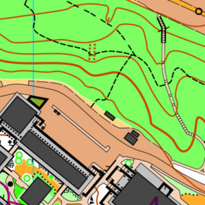
This map is like two venues in one: the hilly and wooded Shoreview Park and the complex campus of Shoreline Community College. Be prepared to switch mental gears as you move between the two!
This venue is mapped to sprint standard (or ISSOM, the International Specification for Sprint Orienteering Maps). The sprint standard has a few key differences from traditional orienteering maps (or ISOM, the International Specification for Orienteering Maps):
- Some features (usually walls) can be marked as uncrossable (illegal to cross)
- Out-of-bounds is represented by olive green, which is used often for flower beds or private areas
- Footpaths and paved areas appear tan
- There are additional urban symbols, including canopies, which illustrate covered passageways
Read more on the map page
SAFETY & ETIQUETTE
Return to the Finish
All participants MUST return to the finish and download their e-punch or turn in their punch card.
Even if you have not finished your course, you must still return to the the finish and confirm with event staff that you have returned safely.
Out of Bounds
Some areas may be marked out of bounds. It is imperative to respect these boundaries to maintain our relationships with land managers. Participants MUST NOT go out of bounds. Any participant caught going out of bounds will be disqualified.
Course Closure
All participants MUST return to the finish by course closure time. If a participant does not return by course closure, event volunteers will begin coordinating a search party.
If you need a long time on the course, start as early in the start window as possible, wear a watch, and be prepared to cut your course short to make it back by the course closure time.
Whistle
All participants MUST carry a whistle on the course. Complimentary whistles are available at the start tent (please only take one).
If you are injured on the course and need assistance, blow three long blasts to call for help.
If you hear a call for help, abandon your course to find the person in distress.
Voices
Part of the fun and fairness of orienteering is navigating your own course, so please be polite when you find a checkpoint and don’t holler that you’ve found it.


