2022-23 Winter League #6 – Camp River Ranch
WINTER LEAGUE
Saturday, January 21 at Camp River Ranch in Carnation, WA
- Parking is at Remlinger Farms. ALLOW yourself 15-30 minutes to walk from the parking lot to start.
- Camp River Ranch is a Pet-Free Zone. Do not bring your animals to this meet.
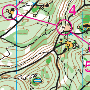
- Site Map is here.
- FINAL START LIST is here.
- Pre-registration is required. There is no day-of-event registration.
- ALL runners will be called to enter the start procedure line 10 minutes prior to their assigned/picked start time. Please Be Race Ready when your name is called.
- See New Start Procedures Here.
- 2022-23 WIOL Rules Here.
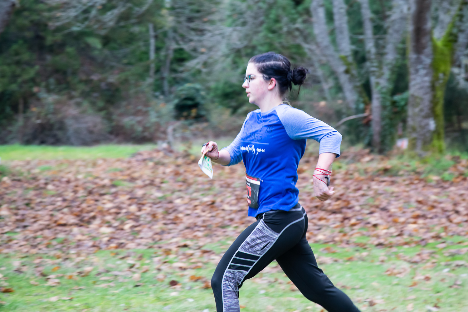
Winter League is the Pacific Northwest’s premier competitive orienteering series for all ages.
- Elementary, Middle School, High School and College students compete under the banner of the Washington Interscholastic Orienteering League (WIOL).
- Winter League public courses offer a range of categories from a competitive long advanced category to non-competitive beginner-friendly categories at every event!
COURSES
Course designer(s): John Brady & Vicki Morella
| Course | Controls | Length | Climb | Map Scale |
| Elementary /Beginner | 9 | 1.1 km | 5 m | 1:5000 |
| Middle School | 12 | 2.1 km | 85 m | 1:7500 |
| Advanced Beginner / JV Rookie | 12 | 2.4 km | 115 m | 1:7500 |
| Intermediate / JV Female | 13 | 2.6 km | 160 m | 1:7500 |
| JV Male | 15 | 3.0 km | 130 m | 1:7500 |
| Varsity | 23 | 3.9 km | 200 m | 1:7500 |
| Short Advanced | 19 | 3.6 km | 180 m | 1:7500 |
| Intercollegiate / Long Advanced | 27 | 4.1 km | 205 m | 1:10,000 |
How are courses measured?
Courses are measured as the crow flies, in a direct line from control to control. Unless you have wings, you will travel farther than this distance! Courses are measured in kilometers, so a good rule of thumb is to simply round up to miles to estimate how far you will go. So in a 5 kilometer race, you’ll likely travel up to 5 miles.
COURSE NOTES
-
Plan an extra 15-30 minutes to get to the starting tent from the parking lot.
- Camp River Ranch is a pet free zone. Do not bring your dog (or other animals) to this meet.
- A few Girl Scout groups will also be onsite at the same time as us. They won’t be using any of the trails, but please be courteous if you see any of them while you are out running.
- Map scale for all courses is set to 1:5000 for elementary, 1:7500 for all other courses except for Long Advanced which is set for 1:10,000
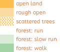
- Trails have not been maintained since our last meet back in February 2019. We have trimmed back as much as we could in most areas; however, some trails were too overgrown. Don’t count on the trail signs as many have been lost to the forest. Be prepared that not all trails are equal in maintenance. Some trails were removed from the map as they no longer exist. A green broken line trail is an unmaintained trail.
- Vegetation has changed over the years, so white on the map will have some groundcover with sword fern. The lightest green has become thicker (“greener” than mapped) but is still walkable. Medium green intensifies in some areas due to more deadfall, vine maple, and other less friendly brush (including some holly and blackberry) that will slow you down. Dark green should generally be avoided.
- This is a girl scout camp, so cabin clusters and other infrastructure dot the venue, allowing for courses that quickly shift tempo between long off-trail navigation legs and quick technical legs in feature-rich areas. You’ll have to use a wide range of skills to be successful here – flowing through controls on short legs, navigating well off trail using contours to keep track of your location, and making the best decision for you to execute each leg well. Watch out for elevation changes when you’re deciding about going straight or around.
- Hazards include slippery trails; steep elevation change and varying levels of vegetation on the off-trail routes. Be wary of icy patches in cold weather.
- All courses other than Beginner/Elementary/Middle School should expect to go off trail. Full leg cover is recommended, although not required. Usage of the compass and contour reading will be useful.
- Some courses will run through the girl scout camp challenge course area. There are “No Trespassing” signs up in this area. You may enter, but do not touch any of the equipment, and keep your head up to watch for cables between trees just off the trails.
- These courses will challenge you to find creative routes and use all the skills in your orienteering toolkit to navigate this classic western Washington terrain. We hope you enjoy the courses!
- On the off chance it snows: Expect to get your feet wet with all the snow and remember that you don’t know what is under the snow – it could be a depression! Have good attack points when you leave the trail and use your compass and terrain features around you to keep on track.
SCHEDULE
This event is Pre-Registration Only
8:45 am PreRace Training Begins
9 am – Info Tent and Newcomer Instruction Opens
9:35 am – Start process begins
9:45 am – First start
12:45 pm – Last Start
1:00 pm – Post Race training begins
2: 45 pm – Course Closure
Why is there a start window?
This event uses an interval start, which means that participants are started in waves instead of all at once. When you arrive at the start tent, find the chute for your course and follow the start volunteer’s instructions.
PRICES
PUBLIC COURSE PRE-REGISTRATION PRICES
$22 base price
– subtract $5 for CascadeOC members
– subtract $5 for using your own e-punch
Become a member here.
Participating as a group? Just $5 for each additional adult (16+) group
member, no cost for additional minors.
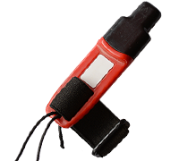
What’s an e-punch?
An e-punch records your race. At each control, you’ll dip the e-punch into an electronic box, which will beep and flash as confirmation. After you finish, you’ll download the e-punch at the download tent and get a receipt that show which controls you visited and how long you took between each; these are your “splits.”
Part of the fun of orienteering is comparing your splits with people who completed the same course, and discussing the routes you took!
SIGN UP
Public registration will close Wednesday 1/18/2023 at 11:59:00 PM.
There is no Day-of-event registration.
Remember to also sign up for a start time for public runners.
LOCATION
PARKING
Parking is at Remlinger Farms. Please do not block folks’ private driveways when parking. See site map here.
Allow 15-30 minutes to walk to start from the parking lot.
CARPOOL
Looking for a carpool? Join the Yahoo listserv and share your request to find a ride.
![]()
SAFETY & ETIQUETTE
Return to the Finish
All participants MUST return to the finish and download their e-punch or turn in their punch card.
Even if you have not finished your course, you must still return to the the finish and confirm with event staff that you have returned safely.
Out of Bounds
Some areas may be marked out of bounds. It is imperative to respect these boundaries to maintain our relationships with land managers. Participants MUST NOT go out of bounds. Any participant caught going out of bounds will be disqualified.
Course Closure
All participants MUST return to the finish by course closure time. If a participant does not return by course closure, event volunteers will begin coordinating a search party.
If you need a long time on the course, start as early in the start window as possible, wear a watch, and be prepared to cut your course short to make it back by the course closure time.
Whistle
All participants MUST carry a whistle on the course. Complimentary whistles are available at the start tent (please only take one).
If you are injured on the course and need assistance, blow three long blasts to call for help.
If you hear a call for help, abandon your course to find the person in distress.
Voices
Part of the fun and fairness of orienteering is navigating your own course, so please be polite when you find a checkpoint and don’t holler that you’ve found it.


