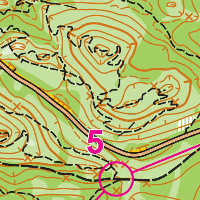
Navigational Challenge Rating: 7
Winding trails through often dense forest provide one type of navigational challenge. But the big, unique challenge here is the frequency of “kettles”–places where ancient glaciers dumped silt and rocks as they melted, actually reversing the expected terrain on the map. What looks at first like a large hill may in fact be the depression left when a large chunk of ice melted. Depression or true hill? Watch your tic marks on the contour lines because the answer changes often!
Physical Challenge Rating: 8
Whenever there are lots of contour lines, there’s a lot of up and down, and this park does not disappoint. Get ready for lots of rolling hills!
Turn-by-turn directions to Fort Ebey State Park
FROM SEATTLE via Mukilteo-Clinton ferry
- Take I-5 North
- Take exit 182 for I-405 N/WA-525
- Keep left at the fork and continue onto WA-525
- Keep left to continue on Mukilteo Speedway
- When you see a ferry lane on the right, enter it
- Take the Mukilteo-Clinton ferry
- From the ferry dock, continue on WA-525
- Continue on WA-20 E for 31 miles
- Turn left onto W Libbey Rd
- Turn left onto Hill Valley Dr
- Follow directions to parking in the campground
The ferry: the Mukilteo-Clinton ferry schedule changes each season, but it generally leaves every 30 minutes and takes 20 minutes to cross. Be aware that lines to get onto the ferry can take as long as 2 hours on a weekend morning.
FROM SEATTLE driving around (no ferry)
- Take I-5 North
- Take exit 230 to WA-20 W/Avon Cutoff
- Continue on WA-20
- Turn right onto W Libbey Rd
- Turn left onto Hill Valley Dr
- Follow directions to parking in the campground