2023 Ultimate Orienteer #5 – South Quincy Lakes (Middle)
ULTIMATE ORIENTEER
Saturday, May 13 at South Quincy Lakes – north access in Quincy WA
Meet Director: Ing Uhlin
Start time signups are open!
Run in the Desert – two days of great orienteering in eastern Washington
 Event #5/8 in the Ultimate Orienteer Series!
Join us as we head east of the mountains with 2 days of great events at South Quincy Lakes.
- Saturday, May 13 – Middle
- Sunday, May 14 – Long
Weather
The weather forecast for event weekend calls for sunny skies with daytime temperatures in the low 90s.
Camping/Lodging
Camping
- Dispersed primitive camping is allowed at the venue
- Wanapum State Park, just south of Vantage, offers camping for tents and RVs and has showers
Lodging
- See Visit Vantage for camping and lodging near Vantage (approximately 11 miles southwest). Vantage is very small and has few facilities.
- Ephrata, approximately 23 miles north, is somewhat larger with several lodging and restaurant options.
- Ellensburg, approximately 40 miles west, has numerous lodging and restaurant options.
- Moses Lake, approximately 35 miles east, also has numerous lodging and restaurant options.
- Many people stay in Quincy, which has more services, including several motels, gas stations, grocery stores, and restaurants. Visit Tour Grant County (scroll down to Quincy) for details.
Other Things to Do
The map terrain and surrounding areas are unique and beautiful. Below are some other things to explore nearby.
- Wanapum Dam
- Frenchman Coulee area
- Gingko Petrified Forest (interpretive center open by appointment only through March)
- Wineries – while there are several in the area, most are closed at this time of year; an exception is Cave B Winery and Resort
- The Gorge Amphitheatre (not much happening in March)
- Wild Horse Monument (a quick stop off eastbound I-90)
Questions
Please check our Newcomers page for general information. If you still have questions, please contact the event director.
COURSES
Course designer(s): Tim Potter, Cory Sytsma
| Course | Controls | Length | Climb |
|---|---|---|---|
| Beginner | 8 | 1.3 km | 55 m |
| Intermediate | 9 | 2.6 km | 170 m |
| Short Adv | 9 | 3.0 km | 130 m |
| Medium Adv | 10 | 3.4 km | 135 m |
| Long Adv | 10 | 5.0 km | 155 m |
Start
The start is approximately .5 mile walk from check-in. Please allow 15 minutes.
Start times are pre-assigned. Sign up for a start time.
What is my age class?
Middle Course/Class Assignments for Ultimate points
If you want to earn Ultimate points, check the table below to see which category you should sign up for.
For example, if you’re a female 16 or under, your Ultimate age class is F-16 and, for this event, is assigned to the Intermediate course. If you are up for a more challenging course, you can also earn points in F-18 or F-20 on the Short Advanced course, or F-21+ on the Medium Advanced course. Just keep in mind that other courses are more difficult, both navigationally and physically, and that you’ll be earning points only in the class you sign up for.
| Age Class | Intermediate | Short Adv | Medium Adv | Long Adv |
| F-16, M-16 | ||||
| F-18, M-18, F-20 | ||||
| M-20, F-21+ | ||||
| M-21+ | ||||
| F50+, M50+ | ||||
| F70+, M70+ |
How are courses measured?
Courses are measured as the crow flies, in a direct line from control to control. Unless you have wings, you will travel farther than this distance! Courses are measured in kilometers, so a good rule of thumb is to simply round up to miles to estimate how far you will go. So in a 5 kilometer race, you’ll likely travel up to 5 miles.
COURSE NOTES
General
- Trails are getting faint – Since this area was mapped, some of the trails have been disappearing. We have updated trails where we found them to be completely gone. In other areas, trails are faint and have been left on the map.
- Cliffs – Not all the smaller cliffs are on the map.
- Water Crossings – There can be a high variability in stream flow in this area. If flow rates are high, you may get your feet wet at a stream crossing. 4 weeks before the event, we could cross all streams without getting feet wet. 2 weeks before, one crossing required some wading.
Courses and Navigation
- Remote Start – The Sunday Long course will have a remote start. There are orange ribbons flagging the route between the time start and the navigation start locations.
- Beginner Course Flagging – There is flagging (orange ribbons) on parts of both the Saturday Middle and Sunday Long courses where the trails are faint.
- Steep Slopes – The Medium and Long Advanced courses are physically challenging and may require ascending or descending steep hillsides or rocky slopes.
Hazards
- Barbed Wire – There is old barbed wire in some areas. It is mostly lying on the ground, but occasionally is at tripping height.
- Water – It is very dry and can be hot. Bring plenty of water to drink depending on how long you expect to be out on the course.
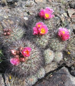
- Cacti – There is a small number of very small cacti on the Western part of the course, probably only an issue for the Sunday long (and possibly medium) advanced courses.
Tim Potter and Cory Sytsma
Course Designers
Water
We will NOT provide water on any courses or at the finish. Please come prepared to carry (and supply) your own water.
Tread lightly
Tread lightly on the land: if the ground is wet, avoid leaving footprints by staying on rocks where possible, not disturbing any rock features such as piles, stacks or cairns, avoiding cactus, and brushing off pants to remove plant seeds before leaving the course.
Sensitive Plant
Snowball cactus (Pediocactus nigrispinus) grows in this area. It’s been designated a sensitive species, so if you see any, please avoid stepping on or near it.
SCHEDULE
Pre-registration only!
- 9:00-11:15am – Check-in
- 9:30-11:30am – Starts (start times are pre-assigned; if you don’t sign up for a start time, you may have to wait in line to start). Sign up for a start time.
- 2:30pm – Courses close*
*Wear a watch to ensure that you return to the finish by course closure time, even if you have to abandon your course to do so. Those returning after course closure will be disqualified and will make the volunteer staff very grumpy.
Why is there a start window?
This event uses an interval start, which means that participants are started in waves instead of all at once. When you arrive at the start tent, find the chute for your course and follow the start volunteer’s instructions.
PRICES
PRE-REGISTRATION PRICES
$22 base price
– subtract $5 for CascadeOC members
– subtract $5 for using your own e-punch
Participating as a group? Just $5 for each additional adult (16+) group
member, no cost for additional minors.
What’s an e-punch?
An e-punch records your race. At each control, you’ll dip the e-punch into an electronic box, which will beep and flash as confirmation. After you finish, you’ll download the e-punch at the download tent and get a receipt that show which controls you visited and how long you took between each; these are your “splits.”
Part of the fun of orienteering is comparing your splits with people who completed the same course, and discussing the routes you took!
SIGN UP
Online pre-registration closes Thursday May 11 @ 9pm Pacific time
There will be no day-of-event registration.
LOCATION
PARKING
Parking is along the road.
CARPOOL
Looking for a carpool? Join the club email group and share your request to find a ride.
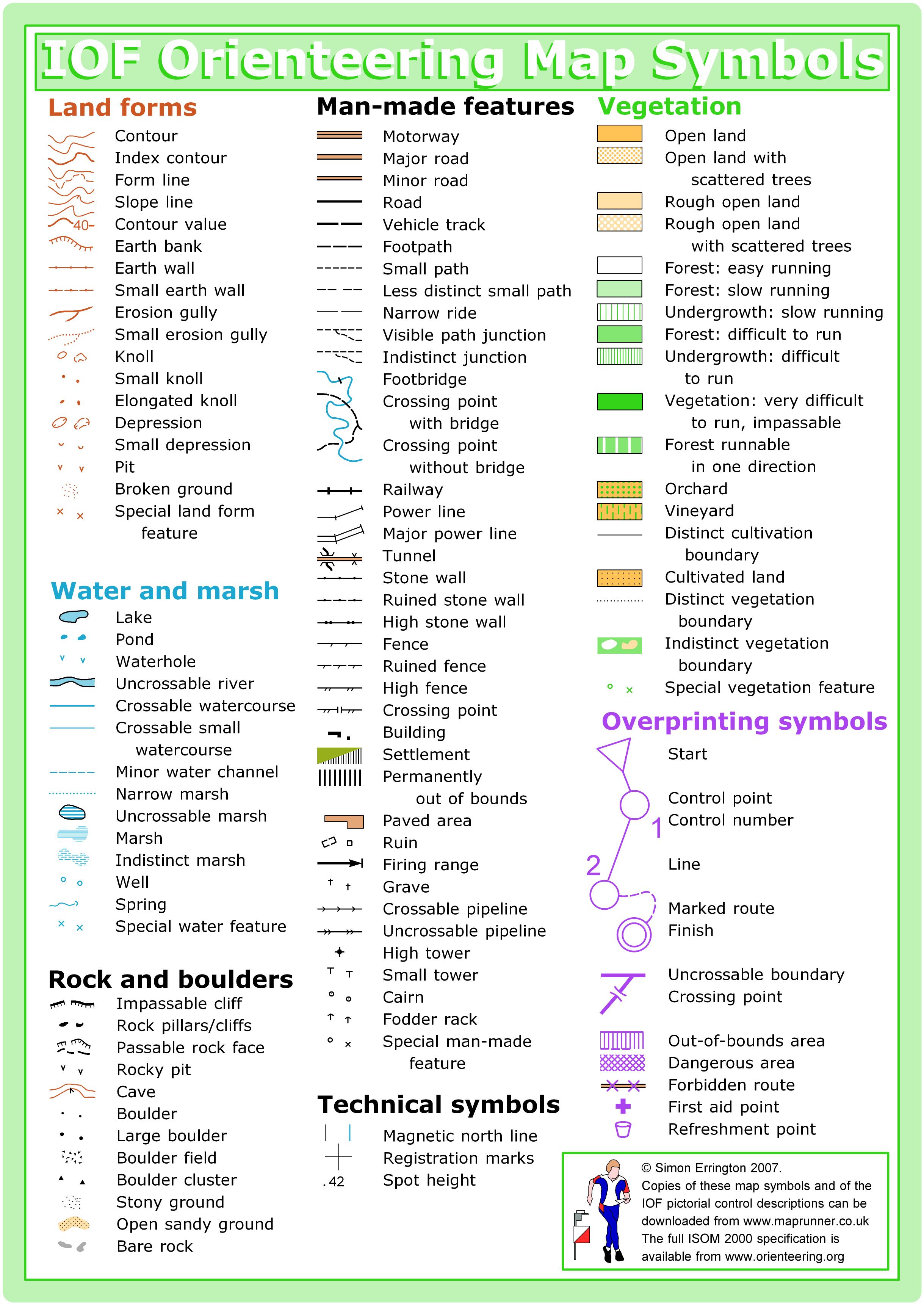
THE MAP
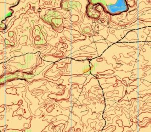
The Quincy Lakes map is owned by Peteris Ledins and maintained by Ott Toomet, who have generously allowed us to use it for some of our events.
- ISOM 2017-2 symbols are used. This map was first created in 2013, but was updated significantly in 2020. A previous version of the map can be seen here: http://www.5z.com/urban/gadget/rg2/#131
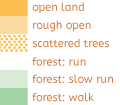
- Vegetation: hard to cross and very hard to cross undergrowth with vertical stripes usually denotes sage bush or other smaller desert vegetation. The exception is near water where water-thirsty plants create hard to cross vegetation.
- Green forest describes higher vegetation, including some trees.
- There are several more distinct trees mapped with the green circle symbol; smaller but distinct bushes are mapped with a green dot.
- There are plenty of cliff faces; please don’t try to cross uncrossable cliffs.
- Ground cover is rocky, be careful with running. More rocky outcrops are marked as rocky ground symbol.
- Rocky ground/bare rock/knoll/rock/cliff – these all can describe rocky features.
- Rock – if the consistency is more uniform.
- Knoll – if it is composed of something that resembles a pile of rocks.
- Small outcrops of rocky ground – very small knolls when the elevation change is insignificant (<1m) yet noticable.
- Cliffs on contour line means that there is significant height and uniform appearance. However, if the cliff is small, but noticeable, or not very uniform, we have used rocky ground symbol cover on contour line.
- Bare rock has been used on uniform rocky features.
- Sometimes you can see rocky “walls” – linear but natural features – when they are uniform, bare rock is used, when less so – rocky ground in the shape of the feature.
SAFETY & ETIQUETTE
Return to the Finish
All participants MUST return to the finish and download their e-punch or turn in their punch card.
Even if you have not finished your course, you must still return to the the finish and confirm with event staff that you have returned safely.
Out of Bounds
Some areas may be marked out of bounds. It is imperative to respect these boundaries to maintain our relationships with land managers. Participants MUST NOT go out of bounds. Any participant caught going out of bounds will be disqualified.
Course Closure
All participants MUST return to the finish by course closure time. If a participant does not return by course closure, event volunteers will begin coordinating a search party.
If you need a long time on the course, start as early in the start window as possible, wear a watch, and be prepared to cut your course short to make it back by the course closure time.
Whistle
All participants MUST carry a whistle on the course. Complimentary whistles are available at the start tent (please only take one).
If you are injured on the course and need assistance, blow three long blasts to call for help.
If you hear a call for help, abandon your course to find the person in distress.
Voices
Part of the fun and fairness of orienteering is navigating your own course, so please be polite when you find a checkpoint and don’t holler that you’ve found it.


